First Alert Day later Tuesday & Tuesday night; one more “chance” for flooding
A Pineapple Express/Atmospheric River remains over region through early Wednesday
We don’t often get short-sleeve weather in December but it happened today!
Today was the warmest December day in 30 years for the Rose City. Temperatures soared into the mid-60s in the I-5 corridor. It tied the all-time December record of 65 degrees. Salem was just 5 degrees from their 68 degree record.
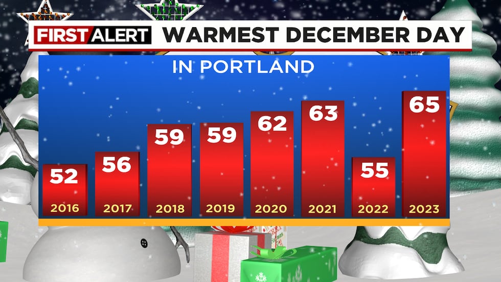
You can see the warmest December days on records going back to 1940

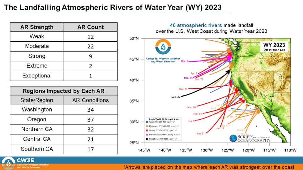
The warmth is caused by the “Pineapple Express” that is centered just offshore; copious amounts of rain are being dumped to our north this evening since it is aimed at BC and Washington right now. This has given rivers and creeks a chance to go back down and a decent day in the lowlands. Unfortunately, rain continues to fall on fresh snow in the Cascades and it’s melting quickly. More rain falls on what’s left of that snowpack through Wednesday morning. Remember a Pineapple Express is just a warm Atmospheric River. They have always existed, but we started calling them “ARs” in the early 2000s. I generally only use either term when it’s significant. Technically maybe 3/4 of our weather systems in the cool season contain an AR; 37 last cool season for Oregon. We only really care about the pink or black lines on this chart that includes all of last year. Those are the events that cause flooding/damage.
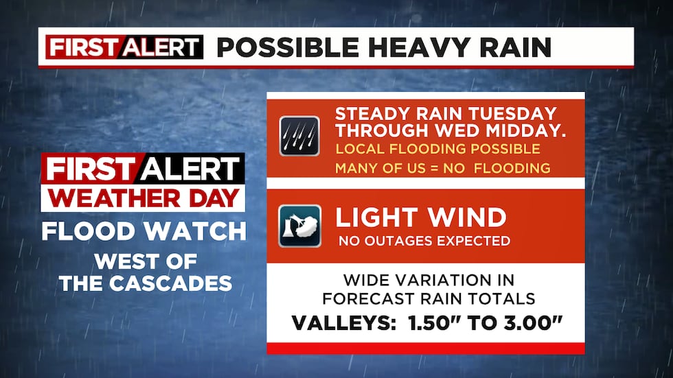
There is no strong wind, snow, or ice in the forecast. But we are in the 3rd day of a Flood Watch in our region, so there’s only one forecast question that matters the next 2 days…will there be enough rain to cause flooding?
Models are in good agreement that steady rain returns late tonight as the pineapple express/atmospheric river moves back south into Oregon and southern Washington. They also generally agree that tomorrow will be a soaking wet day, yep, steady rain the whole day from Salem northward west of the Cascade crest. We also know the rain tapers off Wednesday and the flooding threat ends. But do we pick up just 1.50″ between now and Wednesday morning? That would produce NO FLOODING (like Sunday). Or does 3″ fall by tomorrow night and we get lots of local flooding? Models are a mixed bag, but most are giving us at least 2″. Check out 5 different model forecasts for rain now through sunrise Wednesday. Note the color contours on the map are from GRAF model.
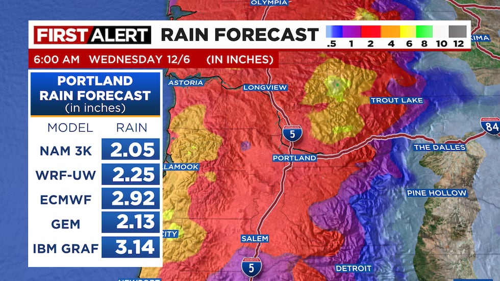
Due to the chance of that 2nd scenario, we’ll call tomorrow a FIRST ALERT WEATHER DAY once again, mainly for the 2nd half of the day and into the evening as the rain totals add up. We do NOT expect any flooding for the morning commute…just a normal soaker. It also appears significant rain doesn’t fall south of Salem at least until later in the day; no threat for flooding down there for at least another 24 hours.
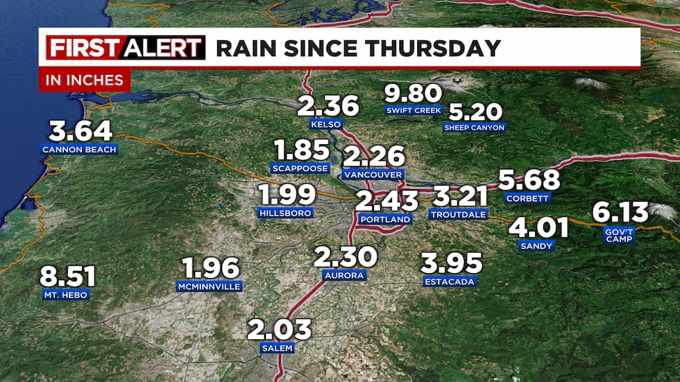
Here are rain totals so far...since December 1st (Friday). It’s slowly adding up...probably 2″ of the Government Camp total was in the form of snow. About 15″ fell at Government Camp before the changeover to rain.
That’s it for this evening, hopefully we can get by with 2″ or less rain for most of us in the next 36 hours.
Copyright 2023 KPTV-KPDX. All rights reserved.