Winter 2024-2025: La Niña is likely on the way back
Mark’s thoughts on the upcoming winter
Each fall people start asking me “What this winter will be like?” or “I’ve heard it’s going to be a bad winter!”. Actually sometimes they start asking in August! For the record, I’ve NEVER had a person say “I’ve heard it’s going to be an easy winter”. People are funny that way, always expecting the worst. Of course we can’t forecast with any sort of detail more than 7-10 days ahead of time, but we CAN glean a few general ideas each year. I don’t put out a “winter forecast”, that’s because seasonal/climate forecasting has a long way to go before we say we can “forecast” a winter. So we’ll just call it “my thoughts” for the upcoming winter.
In the past three winters, the metro area has experienced FOUR big “snow/ice/cold-pocalypse” events that shut down the city and its transportation for at least a day (or 3-4). It would sure be nice to avoid that drama this winter. Is it too much to ask for just a brief 2″ wet snowfall for one morning so the kids can play in it, then it’s gone the next evening???
Winter 2023-2024 Of course all of us remember that cold/icy week this past January that caused so much damage (ice + wind). Take out that one week, and it was a warm and wet (ish) winter. Portland would have experienced a snowless winter without the 1.6″ snow that fell on January 13th as the icy/cold east wind arrived. That was the only measurable snow of the winter. The ski season was terrible leading into and during the Christmas Break (also expected in an El Niño winter). Overall it turned out about as expected. Remember last fall I pointed out that we could get one snow/ice/cold event at some point during a mild mild winter? It happened.

Winter 2022-2023 Two winters back we experienced a 3rd consecutive “La Niña” winter, which means for the 3rd consecutive year the tropical Pacific Ocean was cooler than average. We ended up a little cooler than normal and slightly dry. Here in the metro area we remember two things: very cold air leading into Christmas with freezing rain messing up holiday travel, then the big snowstorm in late February. That was the 11am “I’ve got a bad feeling about this, start calmly driving home” blog post. 10″ of snow fell late that afternoon/evening.

LOOKING AHEAD
It’s hard to believe, but this will be my 33rd winter forecasting here in NW Oregon. I started forecasting professionally in October 1991 straight out of the University of Washington. Many things have changed since then, but there is still a LOT we don’t know about our climate and seasonal shifts in weather. Typically we focus on the La Niña/El Niño Southern Oscillation (ENSO) across the tropical Pacific and what that means for northern hemisphere winters. That is still the case, but other factors play into our winters such as the “Pacific Decadal Oscillation”, warming oceans, maybe solar cycles, etc... So each winter is different and lots more research is needed. We do know that this winter will be either “neutral” or a “La Niña” winter. Most likely the latter. We also know we are still in a “Cold PDO”. First a summary in case you have no plans to read any further:
SUMMARY
- Most likely we have a cooler and wetter than average winter ahead. I’d give that about a 60-70% chance. I feel better about the cooler part vs. wetter.
- Ski season should be reasonable; most La Niña winters end up with good ski conditions. More on this in a following post
- I will be surprised if we don’t get at least one snow/ice event that shuts the metro area down.
- The chance for flooding is higher in winters like these. It has been 28 years since the last major flood event. At some point that’s going to happen again; we just don’t know when.
- Expect fewer east wind episodes than the past two winters. These last two were rough! Good news if you live in east metro or western Gorge
THE WILDCARDS THIS YEAR
- Our winters are getting warmer in the Pacific Northwest due to a warming globe. 2 of the last 3 La Niña winters were normal or warmer than normal in the region. But occasional ice/snow/cold events briefly slip south even in those mild winters.
- Portland is on quite a “consecutive winter snow” streak. For decades PDX never experienced 8 consecutive winters with measurable snow. Now in the last two winters we’ve experienced an 8th and 9th! Last snowless winter was 2015-16. At some point we WILL have a snowless winter in the city. That HAS happened in a La Niña winter in the past (2007-08), so it’s possible.
The ENSO situation right now in the tropical Pacific is NEUTRAL, which means we are not in a warm OR cool event. The latest plume of climate models says we will either be on the “cold side” of neutral or a weak La Niña now through February/March. Anything below -0.5 is considered La Niña on this chart.

Of course every winter we see an active northern Pacific jet stream that brings round after round of rain into the region, plus mountain snow. This is what we tend to see in La Niña winters:
- The jet stream tends to be more “wavy” which means there is more of a north & south component to the jet instead of travelling straight west to east
- There is increased tendency for blocking (high pressure) somewhere in the east Pacific, just to our west, leading to dry periods.
- As a result there is sometimes more interaction of the cold Canadian air to the east and Pacific moisture with the jet stream weakening dramatically at times too.

It’s important to point out that though many La Niña winters follow this pattern, sometimes they don’t. No guarantees! The last three winters like this saw just average precipitation AND ended up with near normal or above-average temps! Maybe even more interesting is that La Niña winters since 2000 have averaged DRIER than normal...
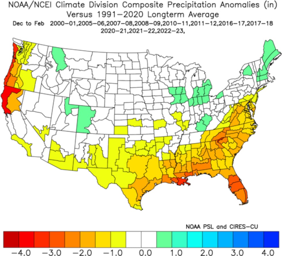
but those in the previous 30 years were wetter than average, did something change around the turn of the century? Good question

WIND STORMS?
We are “overdue” for a regionwide major windstorm here in the Pacific Northwest. The last BIG one was December 1995. That’s 29 years ago! 14 years before that we had the major November 1981 storm. It’s interesting that all the La Ninas from 1950 to the mid 70s had a wind gust of 60+ mph at PDX each time! Not as frequent since that time though.
LOWLAND SNOW
Of course what everyone really wants to know is…will it snow at MY house this winter???
We sure have seen lots of snow the last 8 winters. In previous decades we’d go 1, 2, or even 3 consecutive winters without snow in the lowest elevations! As mentioned, we’ve had some sort of snow in each of the last 9 winters, a new record at PDX. Note that we’ve seen a big snowstorm in 1/2 of the last 8 La Niña winters. This makes me think the odds are good that we get at least one snow “event” this winter.

One more point…one of the most hated parts of winter for part of the metro area is the cold east wind. The Columbia River Gorge produces what we call a “gap wind” when high pressure east of the Cascades sends air rushing through the sea-level gap through the mountains. The east side metro area near and south of the Columbia River is fully exposed to the wrath of this wind. The cold wind appears in late October and reaches a peak from November through February. Then the wind disappears in early March as the seasonal westerlies begin. The last 18 winters at Troutdale airport below. Any day with an easterly gust over 25 mph counts.

Does La Niña mean more or less east wind? Based on my experience, it’s generally a case of LESS east wind or at least just typical conditions. That’s because during El Niño years, we have a split or blocked jet stream more often, leading to more time under surface high pressure. And much of the time that is centered east of the Cascades. Notice the some of the most consistent easterly wind the past decade was during the El Niño events in 2014-15, and 2015-16, and 2023-24.
In a future post (Wednesday), I’ll take a look at what we might see in the Cascades and how this all may affect the ski season.
Copyright 2023 KPTV-KPDX. All rights reserved.